By Kim Hernandez, Coastal Resources Planner at the Maryland Department of Natural Resources. This article is also published on Marine Science Today as part of a TCS-MST Collaboration initiated earlier this year.
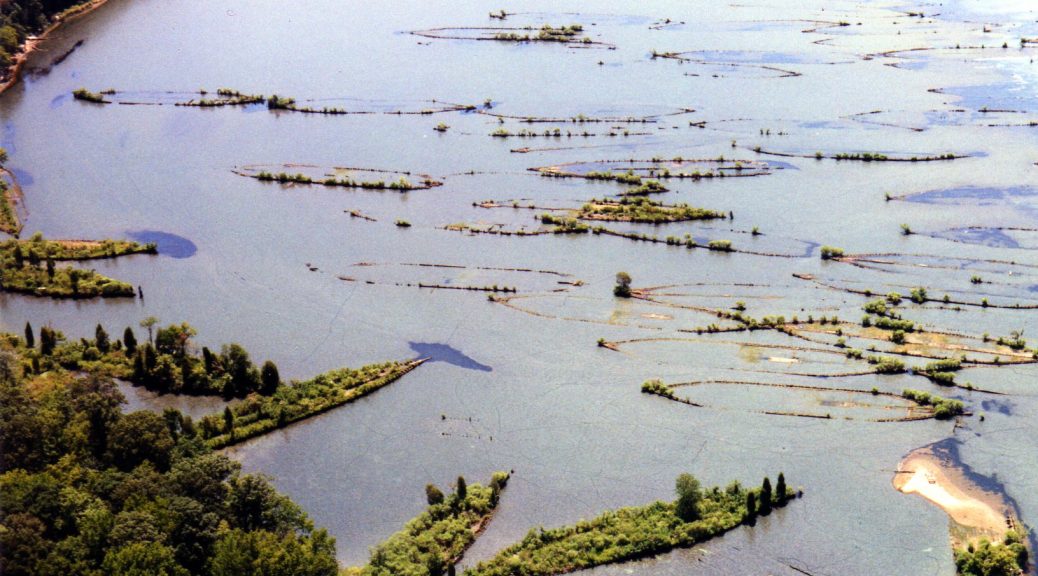
In the tidal Potomac River, about 30 miles downstream from Washington D.C., lay the remains of the “Ghost Fleet of Mallows Bay” – over 100 wooden steamships built for the U.S. Emergency Fleet as part of the nation’s engagement in World War I. Dozens of other historic maritime resources also rest in the Potomac River, as well as 12,000 year old archaeological artifacts dating back to some of the region’s earliest Native American cultures. The significance of the area was enough to warrant its listing on the National Register of Historic Places in 2015. Now, thanks to abundant community support, it is in the running to become Maryland’s first national marine sanctuary.
One of the World War I shipwrecks visible at low tide in Mallows Bay, Maryland. Photo Credit: Kim Hernandez.
The National Oceanic and Atmospheric Administration (NOAA), the federal agency with authority to designate an area as a sanctuary, for the first time in two decades has been seeking engagement from the American public to nominate areas with significant community support. As nominations are submitted, NOAA reviews each one in several steps and those that pass the review will be added to an inventory of areas NOAA may consider for potential designation as national marine sanctuaries.
The Mallows Bay-Potomac River National Marine Sanctuary nomination was submitted in September 2014 by the State of Maryland with a broad-base of local government and non-government support. The nomination itself included letters of support from over 60 community organizations and individuals. Sanctuary designation would allow NOAA programs to supplement and complement existing state and local programs that aim to protect, study, interpret, and manage this unique area.
The original nomination cited improved opportunities for public access if the area is designated a sanctuary. Photo Credit: Stephen Badger.
In addition to protecting the fragile remains of the shipwrecks, the nomination also cites opportunities to expand public access, recreation, tourism, research, and education. The area is contiguous to the Captain John Smith Chesapeake National Historic Trail, the Star Spangled Banner National Historic Trail, the Potomac Heritage National Scenic Trail and the Lower Potomac Water Trail, allowing paddlers a unique glimpse into our Nation’s history. Below the water, the area offers important habitat for popular recreational fisheries, including Striped Bass and White Perch. Above the water, ghostly shipwreck hulls jut out and provide perches for migrating waterfowl and thriving populations of Bald Eagles. The middle Potomac River truly is a historic and ecological treasure.
Four months after the original nomination was submitted, NOAA announced it would add the area to the inventory of nominations that are eligible for designation. It is important to note that the original nomination in September 2014 did not designate anything; it only suggested that NOAA consider designation. The January 2015 announcement meant NOAA would now seriously consider a sanctuary in the Potomac River – a huge step forward for the dozens of community supporters.
The ghostly shipwreck hulls lure recreationalists and historians to this area of the Potomac to get a unique glimpse into the past. Photo Credit: Kim Hernandez.
Nationally, the designation process is a separate public process that, by law, is highly public and participatory and often takes several years to complete. Nominated areas go through four main steps with NOAA before it is determined whether they are designated or not: (1) Scoping: NOAA announces its intent to designate a new national marine sanctuary and asks the public for input on potential boundaries, resources that could be protected, issues NOAA should consider and any information that should be included in the resource analysis; (2) Sanctuary Proposal: NOAA prepares draft designation documents including a draft management plan, draft environmental impact statement that analyzes a range of alternatives, proposed regulations and proposed boundaries; (3) Public Review: The public, agency partners, tribes and other stakeholders provide input on the draft documents. NOAA considers all input and determines appropriate changes; and (4) Sanctuary Designation: NOAA makes a final decision and prepares final documents. Before the designation becomes effective, the Governor reviews the documents. Congress also has the opportunity to review the documents.
Many birds, such as the osprey pictured here, have built nests atop the shipwrecks. Bald eagles are also often seen nesting along the shoreline. Photo Credit: K. Thayer.
For Mallow’s Bay, NOAA considered the nomination action until October 2015 when they issued a formal “Notice of Intent” to designate. Along with the Wisconsin – Lake Michigan National Marine Sanctuary, which is going through this same designation process right now, the Potomac River has the potential to be the home of one of the first new national marine sanctuaries designated in nearly 20 years.
In early spring 2016, a federal, state, and local government committee formed to grapple with all of possible management questions a sanctuary designation could spark. Currently, that committee is developing the draft documents required for the sanctuary – including an environmental impact statement and management plan. If all goes as planned, drafts will be available for public comment sometime in late 2016 and designation of this World War I paragon will coincide with the 100-year anniversary of the United States’ entry into the world war, in April 2017.
Sanctuary designation will allow NOAA programs to supplement and complement existing state and local programs that aim to protect, study, interpret, and manage this unique area. Photo Credit: Daryl Byrd.
If designated, the proposed sanctuary would be managed jointly by NOAA, the State of Maryland, and Charles County, Maryland. The original coalition of organizations and individuals at local, state, regional, and national levels that supported the nomination – including elected officials, businesses, Native Americans, environmental, recreation, conservation, fishing, tourism, museums, historical societies, and education groups – will continue to help mold the vision for the sanctuary and ensure effective protection and management moving forward.
For more information about the National Marine Sanctuary Program and nomination process, visit: http://www.nominate.noaa.gov/
Kim Hernandez is a Coastal Resources Planner with the Maryland Department of Natural Resources Chesapeake and Coastal Service. She assists with the coordination of state and regional ocean planning, with the planning and implementation of the Mallows Bay – Potomac River National Marine Sanctuary, and with programs that address coastal hazards and climate resiliency. She also serves as the agency representative on a number of planning bodies and stakeholder groups throughout the Mid-Atlantic region.
Editor’s Note: TCS members working on a national marine sanctuary nomination are invited to contribute a story on your proposed site and current efforts moving through the nomination process. Story ideas or full submissions can be sent to the TCS Communications Chair at kaseyrjacobs (at) gmail (dot) com.
By: Lisa Graichen, Stakeholder Engagement Associate for the Great Bay National Estuarine Research Reserve (TCS Communications Subcommittee Member).
If you ask a handful of people what they think about wetland and riparian buffers, you will likely get quite a range of responses. Some identify a clear connection between buffers and their benefits for protecting clean water and other values; others see it as a significant impediment to development and growth; and many probably have no idea what you’re talking about.
Vegetated shoreland along Sagamore Creek in Portsmouth, New Hampshire. Around tidal wetlands, Portsmouth requires a vegetated buffer strip to 25’ and a limited cut area from 25’ to 50’ (Photo Credit: Lisa Graichen).
Wetland and riparian buffers – areas around water bodies in which removal of vegetation and other activities are either entirely or partially restricted – are essentially a tool in the toolboxes of municipalities and states to protect clean water and healthy, functioning ecosystems. At face value, buffers might sound simple and straightforward – if you leave natural space, particularly with vegetation, between water resources and nearby human activities (e.g., residential or commercial development, agriculture, roadways, etc.), you might expect a number of benefits. Buffers are known for quite a few functions, from providing wildlife habitat to protecting clean water by intercepting nutrients and contaminants from runoff, reducing sediment inputs, slowing down flows, reducing water temperature by providing shade, and promoting infiltration. In addition to the associated benefits for drinking water supplies, buffers provide other human-related benefits like flood storage and bank stabilization, aesthetic value, and recreational activities. Some interesting studies have also shown that proximity to green space can improve quality of life and property values.
A significant amount of scientific research has been done to better understand and, in some cases, to quantify the ecological functions of buffers. And while the recommended width of the buffer can vary based on the primary functions that need protection, the benefits of buffers are pretty clear. However, things can get a little murky where buffers intersect with the human dimension. I’m working on a project with the Great Bay National Estuarine Research Reserve and other partners that’s looking at the scientific, regulatory, economic, and social dimensions of buffers in the Great Bay Estuary and its watershed. Here are a few lessons I’m learning about buffers:
1) Buffer regulations are hard to implement.
In New Hampshire, municipalities have the option to develop and implement a wetland buffer ordinance. The state is responsible for enforcing the Shoreland Water Quality Protection Act (SWQPA), which provides for vegetated and managed buffer zones around certain surface rivers, lakes, and ponds. Municipalities can enact requirements above and beyond the SWQPA if they so choose.
There are a number of logistical challenges to implementing buffers at the local level. First, not all communities have a full-time code enforcement officer, and even if they do, this person has a lot of responsibilities in addition to enforcing buffers. Also, “policing” the town for buffer violations would be time consuming and probably not very popular. It often falls on neighbors to report complaints about activities or impacts in the buffer, which is not a very positive or proactive situation. Another challenge is knowing where the wetland boundaries are. Wetland boundaries can be dynamic, and the delineation can have a significant impact on how buffer limits are identified and how the site is ultimately designed.
As an example of the difficulty of implementing buffers, some communities have a “no clearing buffer zone” policy that restricts cutting of trees and vegetation to no more than 50% of the basal area per year. Enforcing this would necessitate knowing what the basal area is and monitoring change annually. (Basal Area is the area of the cross section of a tree stem, including the bark, generally at breast height about 4.5 feet above the ground.) This isn’t to say that communities shouldn’t have this kind of language in their ordinances – it does provide some teeth in the event of an obvious, egregious violation – but it’s important to acknowledge the challenges it presents in implementation.
2) Buffers can be controversial.
Through this project, I’ve come to realize that buffers are not nearly as straightforward and innocuous as I initially (naively) thought! In some communities, buffer-related initiatives (e.g., efforts to either weaken or strengthen the buffer ordinance) have led to heated public meetings and contributed to strained relationships between municipal boards and even between neighbors. Some see buffers as a positive and necessary tool for protecting clean water and other values; others see buffers in a very negative light, as an infringement on property rights and property values, a restriction on development and growth, and an example of government overreach. The word “taking” comes up frequently, sometimes with threats of lawsuits.
Buffers are a way to protect shared public resources, but the immediate impact can feel unevenly dispersed across the community, as not all parcels have wetlands or shorefront. Sometimes the impacts can be uneven across the watershed as well; for example, downstream communities benefit from effective buffers implemented in communities upriver.
3) The regulatory framework for buffers varies from community to community and state to state.
Buffer ordinances can vary significantly from one community to the next, from no buffer to a 25’ no cut-no disturbance buffer, to a 50’ or larger limited cut or managed buffer. Implementation capacity also varies between communities, contributing to different results despite what’s in the ordinance. Towns can even differ in their decision-making process, the amount of information they require from applicants, and the strictness with which ordinances are implemented. Buffer regulations and the decision-making process also vary significantly between states.
This variability can be challenging for developers who have to navigate different regulatory frameworks, and also for newcomers who move to a new town and may not be aware that the requirements and processes might be different. In addition, this can create a sense of competition between towns, or a fear, warranted or not, on the part of some stakeholders who want to see more development and growth in their town that if their buffer regulations are stricter than those of neighboring towns, developers may look elsewhere.
4) Buffers bring up a lot of value judgments.
Wetland buffers around New Orleans, Louisiana like the Central Wetlands Unit, provide a variety of services such as pollution filtering, natural storm protection for the people living nearby, and others (Photo Credit: Kasey R. Jacobs, The Coastal Society).
Whether intentional or not, buffers are tied to people’s visions for the town’s future and perspectives about growth. There are inevitably some differences of opinion about this, particularly as towns are facing rising development pressures and seeing influxes of newcomers who lack the tie to the town’s past and character. Also, support for protective measures like buffers depends on an underlying sense of connection to natural resources and an understanding of their benefits. For example, one key benefit of buffers is protection of drinking water sources. However, if people lack an awareness of where their drinking water comes from, it might be difficult to see the direct benefits of buffers.
5) Buffers also bring up the issue of shifting baselines, a challenge that often arises in many coastal management issues.
As memory of the past state of natural resources is lost, the connection to the reasoning and need for buffers can weaken. Many communities are seeing changing population dynamics, with a combination of longtime residents and newcomers. The newcomers may not be aware of how abundant resources were or how healthy ecosystems were in that area’s past, and so the current state becomes their baseline. And with turnover in decision-makers, institutional memory and the original rationale for buffer regulations can get lost as well.
A way forward for buffers?
If nothing else, I hope that this article makes clear how complex buffers can be. There are many different layers – regulatory, ecological, and social – and it’s important to understand them all in order to effectively use buffers as a tool to protect water resources and maintain the many functions they provide. Buffers offer a low-cost way to protect drinking water, reduce damage from flooding and erosion, and reduce the cost of water treatment and stormwater management, as well as a host of other benefits. It’s clear that we need to promote a broad, underlying awareness of the importance of these ecosystem services in order to foster support for buffers.
Comment below to share your stories about how buffers work in your state or communities! What are the perspectives and concerns related to buffers that you encounter? What are the challenges? Any ideas for innovative approaches to buffers? What resources or information would be helpful?
Lisa Graichen works as a Community Engagement Specialist with the Great Bay National Estuarine Research Reserve in New Hampshire. She is working on a number of projects, including Buffer Options for the Bay. Lisa has been with the Reserve since September 2015. She also is a member of the TCS Communications Subcommittee and a volunteer with the Stewardship Network of New England. Lisa is a 2015 graduate of the TIDES program (Training for the Integration of Decision-making and Ecosystem Science) at the University of New Hampshire, a master’s program focusing on coastal ecosystem management, during which she interned at the Hudson River National Estuarine Research Reserve in New York. Outside of the office, Lisa enjoys hiking with her dog Baxter and exploring local rivers by kayak or paddleboard.
The Eckerd College chapter of the Coastal Society has been working to clean up coastal environments on and around our beautiful campus! Eckerd College is a small liberal arts college in St. Petersburg Florida sitting on the beautiful Gulf coast. Eckerd College has a small but environmentally conscious student body. The coastal and marine environment proves to be a major draw for Eckerd College students. With over a mile of coastline on our campus alone, students are constantly interacting with the coastal environment. The campus waterfront, situated on Frenchman’s creek near the opening into Tampa Bay, allows students to make regular kayak trips, swimming breaks, and even sailboat rides straight from the school. Service and volunteer work within the community is a high priority for our students, and even part of our graduation requirements. The Coastal Society is just one important group on campus that includes a variety of volunteer outreach opportunities. As the first undergraduate program to have a Coastal Society chapter, it provides a great resource and opportunity for students.
Our first beach cleanup of the year took place last semester and was set at Fort DeSoto, a Pinellas county park with some of the most beautiful beaches in the area. This natural area is the largest park in the county, with 1,136 acres of land comprised of 5 interconnected islands. Not only is this a popular area for tourists and locals looking to soak up the sun, but it is also a permanently protected area by the state. Even though the park has full time staff to manage the area, they still need volunteers to help keep the area clean. Eckerd’s chapter of TCS joined with the managers last semester to spend one Saturday cleaning up one of the most popular beaches. This area remains a high priority for managers due to it’s close proximity to a bird sanctuary, where numerous shore nesting species are protected.
At the start of the Spring semester, we held our second cleanup event on our own campus. A large percentage of Eckerd College students live on campus all four years, making recruiting additional volunteers easy on such a beautiful, sunny Saturday afternoon. While our student body does it’s best to help keep our campus clean, garbage still gets strewn along our coastlines from incoming surf and thoughtless litterbugs. The volunteers set out to pick up debris along the beaches and in the mangroves on campus. By the end of a few hours, the volunteers had collected 6 full garbage bags and a full size-recycling bin of waste.
Both of these cleanups have not only helped benefit our community’s coastal areas, but also have helped spread the word about what The Coastal Society is and the kinds of things we are involved in. Finding like-minded individuals, who not only work in coastal communities, but also care about the environment that they work in can be extremely beneficial to all parties involved. Eckerd College’s chapter hopes to do more of these kinds of cleanups soon, and keep spreading the word! ?
By Lisa Graichen, Community Engagement Associate for the Great Bay National Estuarine Research Reserve (TCS Communications Subcommittee Member)
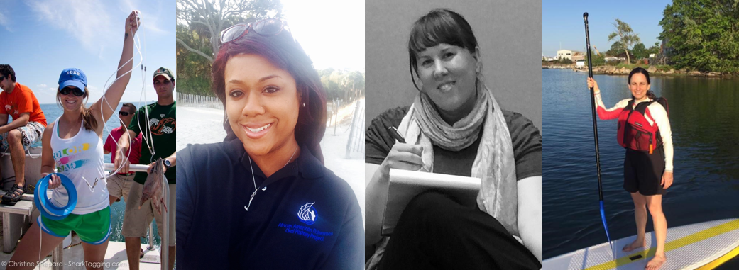
The Coastal Society welcomes its newest members of the Board of Directors: Caitlyn McCrary, Tiffany Smythe, Jolvan Morris, and Michelle Lennox. These new board members bring diverse expertise and enthusiasm for coastal management to the organization. Lisa Graichen interviewed each on behalf of the TCS Communications Subcommittee so that TCS Blog readers can learn more about these wonderful people, what they’re most excited about in the coastal management field, what some of their biggest coastal concerns are, why they decided to join the TCS board, and more!
Communication Specialist with NOAA’s Office for Coastal Management in Charleston, South Carolina
What has your career path been like leading up to where you are now?
So far, I’d say my path has been short. I’m still early in my career but I do think I’ve learned a good bit in getting where I am now. From undergrad I went straight to graduate school. I knew that bench science wasn’t for me, and I found a program that focused on the business and management sides of coastal science. From there, networking and taking advantage of the resources I had became key. I found alumni from my grad program working for NOAA’s Office for Coastal Management, reached out, and asked if I could be a summer intern. I incorporated that work into my master’s thesis and when I graduated, they created a position for me based on that work.
Do you have any career-related advice for folks working in the coastal management field?
Network! The saying “it’s all who you know” hits the nail on the head. That’s why organizations like TCS and going places to actually meet people are still so key. You can accomplish almost anything with a dedicated network of people working together.
What do you enjoy most about working in this field?
The feeling of making a difference. Helping our coasts reaches to so many other aspects of our lives. It’s amazing to be a part of that.
What are your biggest concerns for coastal management today?
The people who think, “Out of sight, out of mind.” They’re the ones who think their house won’t flood, the storm won’t hit their area, or it won’t happen during their generation. They see the photos of island nations sinking as too far away to really matter because if it’s not happening to them, why does it matter? They therefore don’t invest in the solutions we, as coastal managers, propose, which makes our jobs harder.
What most excites you about the coastal management field today?
That the number of people who don’t understand climate change and don’t think it’s happening to them is decreasing. Our field is doing a great job getting more city and county governments to realize this is a serious issue and they need to do something about it. Hopefully that will turn into a snowball that just keeps growing.
Why did you decide to join the TCS board? What is your main goal for TCS?
I joined because Matt asked me to ? In all seriousness, I want to help keep our organization relevant. There are so few good organizations for people involved in our coasts or ocean but who aren’t doing “hard” science. We need to fill that void and keep up with the strong work we’ve started by fostering the next generation of coastal managers and strengthening the bonds within our field.
Is there anything else you’d like to share with TCS members as a new board member?
Don’t be afraid to reach out if you have questions or comments. I know our new members often feel a little overwhelmed and lost or maybe older members have great insight on things we could be doing –email me, please!
What are some of your favorite things to do outside of work?
Running, hanging out with friends and family, watching University of South Carolina football, and traveling as much as possible!
Coastal Management Extension Specialist, Coastal Resources Center/Rhode Island Sea Grant, and Adjunct Professor, Department of Marine Affairs, URI Graduate School of Oceanography
What has your career path been like leading up to where you are now?
I am a Coastal Management Extension Specialist with the Coastal Resource Center and Rhode Island Sea Grant at URI Graduate School of Oceanography, and I’m also an adjunct professor of marine affairs at URI. I have my master’s and PhD in marine affairs from URI, so I’m an alum, too. Along the way I’ve also worked in the nonprofit sector, in government, and in academia, trying to gain experience in many different sectors. Other places I’ve worked include the U.S. Coast Guard Academy and Sea Education Association – two very different academic institutions.
I’ve devoted a lot of my recent career to marine spatial planning/ocean planning and offshore renewable energy development. I was a co-author of Rhode Island’s ocean plan, which we developed back in 2008-2010. That plan led to the siting of what will be nation’s first offshore wind farm here in Rhode Island. We’re now supporting other organizations doing similar kinds of planning, and we’re doing research and outreach related to the wind farm because it’s such an important, historic effort. The wind farm is under construction right now and is scheduled to be operational by late 2016. It’s super exciting!
Do you have any career-related advice for folks working in the coastal management field?
I’ve found it valuable to let my career take me into different sectors related to coastal management – nonprofit, government, academia, and even consulting (I ran my own consulting firm for a little while). It’s been really helpful to have that diversity of experience to understand the ways different organizations interact in the coastal management sphere. For example, the nonprofit I worked at was much more advocacy-oriented, whereas being an academic or working in extension like I do now, there’s much more of an emphasis on objectivity, and in government there is an emphasis on staying out of advocacy. It’s important to see coastal management issues from the perspective of all the different sectors.
What do you enjoy most about working in this field?
Well, I love the ocean. I got into this field because I’m a sailor. I used to work professionally on sailboats. I love getting to work on, near, around the ocean with people who care about it, with people who use it.
What are your biggest concerns for coastal management today?
There are tons! One concern I have is the lack of political will and associated funding to support effective coastal and ocean management and planning. I think it’s important for us to figure out how to maintain a strong bipartisan constituency for ocean and coastal protection.
What most excites you about the coastal management field today?
I’m excited by offshore renewable energy. It’s been a privilege to get to be front and center on our nation’s first such project. Also, I’m excited by what I think is becoming broader public awareness and support for climate change-related issues. We have a really long way to go, but I think I’ve seen a bit of a shift over time to broader recognition of this as a problem we need to deal with.
Why did you decide to join the TCS board? What is your main goal for TCS?
I was involved with TCS first as a grad student and by attending TCS conferences. Taking advantage of some of the student opportunities really helped me in my career, and I made some key professional contacts I still utilize. I felt that it was a good time for me to give back to the organization and to help current students and future professionals. I also think this is a transitional time for TCS, so my goal is to help the organization figure out how best to support the coastal management community, given all of the changes, financial and otherwise, in our field.
Is there anything else you’d like to share with TCS members as a new board member?
I would ask for TCS members to think actively and be vocal about what they want to see TCS do or offer to the community. Really think creatively and share your ideas with board members, and then get involved on committees. The only way we’re going to grow the organization and make it relevant for the next generation is if people say what they want and step up to make it happen.
What are some of your favorite things to do outside of work?
I’m pretty outdoorsy and athletic – stand-up paddleboarding, sailing, kayaking. I spend a lot of time on the water recreationally.
What has your career path been like leading up to where you are now?
I just finished a post-doc in the NOAA Living Marine Resources Cooperative Science Center at Savannah State University. While at Savannah State, I was doing a little bit of teaching but mostly helping on student research that focused on socioeconomic impacts of fishing in coastal communities. I conducted my own research that focused on historic African American fishing communities, and during the summers assisted in collecting brittle stars for ongoing research in the benthic lab. It was a good mix of the research, teaching, and fieldwork. I recently accepted a position with the Greater Atlantic Regional Fisheries Office (GARFO), so I’m going to be working in the Protected Resources Division on Section 7 consultations and related tasks for energy projects. I’ll also be working on projects for the ongoing K-12 Sturgeon outreach program in the region. This new assignment connected back to my master’s research. I participated in an NOAA internship when GARFO was called the Northeast Regional Office. Back then I worked with the sturgeon team on projects related to Section 7 consultations for shortnose and Atlantic sturgeon. My master’s work was based on that internship experience. My recent career transition is a good way to revisit what I did in grad school and to put that knowledge to use.
Do you have any career-related advice for folks working in the coastal management field?
Find an awesome mentor. Build your professional network. Go to conferences and meet people who might be able to help you get those internships, and just learn as much as you can from every experience because you never know what direction you’re going to be heading.
What do you enjoy most about working in this field?
I enjoy working with people who have the same interests and passions as I do as far as being outdoors, on the water, and working in the environment. I earned my graduate degree in environmental science, and I chose fisheries because I have a passion for the water and environmental stewardship. I enjoy just being around people who share that common interest and being able to make a difference.
What are your biggest concerns for coastal management today?
One of my concerns is development – people building on the coast without regard for the impacts that it’s going to have later on down the line, especially with climate change and all of the uncertainty involved. We don’t really have that great of a grasp on the future impacts of what we do now, so I think we should take a precautionary approach. We need to make sure we’re making the best policy and management decisions that we can so that we’re not creating more problems than we solve.
What most excites you about the coastal management field today?
Coming from a background of environmental science and having worked in outreach and education. What excites me is the fact that a lot more schools are educating younger people on it. Those opportunities for outreach and getting the next generation involved in being proactive – that’s what excites me.
Why did you decide to join the TCS board? What is your main goal for TCS?
I joined the TCS board because of a mentor, Tom Bigford. I had a chance to meet Tom at a NOAA Educational Partnership Program conference that I attended during my post-doc and again at an AFS meeting in Savannah. In conversation, I mentioned to him that I had been the recipient of the Thomas E. Bigford Award for Best Student Presentation at a TCS forum during grad school. He later encouraged me to apply for the TCS secretary position and to be more involved. I did, and I was able to learn more about the organization and become an active member. I’m interested in moving the organization forward and continuing the good work. Also I’m interested in being a voice to represent more diversity in TCS. We’re a diverse country, so we should have that reflected in our organization as well.
What are some of your favorite things to do outside of work?
I’m a new mom, so I’m spending time with my little one. I also like to travel, go to the beach, go hiking with my dogs, take rides on my motorcycle, go fishing, and just be outdoors.
Biologist and National Transportation Liaison, NOAA Fisheries in Silver Spring, Maryland.
What has your career path been like leading up to where you are now?
I’ve worked in state (mid-Atlantic) and federal government (Canada and U.S.), in academic and nonprofit institutions, and at an environmental consulting firm. I’ve worked on a range of issues over the past 20 years, including ecotoxicology, climate change, Chesapeake Bay restoration, environmental regulatory compliance, marine and coastal conservation finance, ocean planning, and marine protected resource conservation. This mix of experiences has led me to my current position at NOAA Fisheries, Office of Protected Resources, where I get to work on trying to reach a balance between conservation and much-needed infrastructure through advancing sound science, partnerships, policy, and management.
Do you have any career-related advice for folks working in the coastal management field?
Solicit and develop relationships with the individuals you come across in coastal management (through school, volunteer opportunities, internships, jobs, etc.), and nourish and maintain those relationships over the years. It’s a small and connected community, and the connections you build will benefit you at times when you least expect them. Also, conferences and coastal management events end up feeling like a family reunion!
What do you enjoy most about working in this field?
I get to work with wonderful, smart, and passionate people. Our field draws talented and selfless people who work tirelessly on the important mission of coastal management, conservation, and protection. That shared drive to protect our environment makes for a wonderful community of incredibly cool people.
What are your biggest concerns for coastal management today?
How our leaders and decision-makers choose to address climate change will dramatically affect the future of our coastal environments, economies, and communities. My biggest concern is that dramatic changes to reverse the trend of climate change and its impacts will happen much too late.
What most excites you about the coastal management field?
I’m excited by the development of spatial and visualization digital tools. Being able to tell persuasive stories is an important element of our work. Using mapping and visualization tools to demonstrate scenarios (for issues like sea-level rise, expanding ocean uses, and changing ocean temperatures) to decision-makers and stakeholders is an incredibly powerful storytelling method.
Why did you decide to join the TCS board? What is your main goal for TCS?
It was an opportunity for me to engage with respected experts outside of my immediate coastal management network, and a chance for me to use my fundraising skills to help identify sustainable funding mechanisms to support this organization that has such a rich history in our community.
What are some of your favorite things to do outside of work?
Spending quality time with my awesome husband and our elderly rescue Chihuahuas, sampling microbrew beers, enjoying the great outdoors, going to rock n’ roll shows, and napping.
—
Thank you, Caitlyn, Tiffany, Jolvan, and Michelle, for bringing your knowledge, ideas, and dedication to the TCS board. To other TCS members, these board members want to hear from you, so please feel free to reach out!
By: Meg Gardner, Environmental Programs Coordinator for the Oregon State Marine Board (TCS Communications Subcommittee Member).
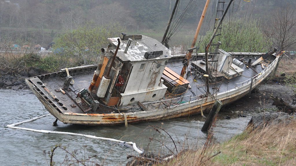
When most people think of marine debris, they think old fishing gear, plastic bags, or cigarette butts. But another category of debris exists that challenges coastal managers throughout the U.S. – abandoned and derelict vessels (ADV’s). This term covers anything from a 10-foot aluminum dingy left on a public boat ramp all the way up to a 100-foot former commercial fishing vessel with barrels of unknown hazardous materials onboard and anchored out on a river. Typically, an abandoned vessel is defined as one that has been left without authorization on public or private lands, and a derelict vessel is one that is sinking, sunk, leaking pollution, or a threat to public health and safety.
This vessel fell apart soon after being removed, evidence of its poor conditions. The vessel in the feature image of this article had to be contained due to leaking oil and then removed. Photo Credit: Oregon State Marine Board
Vessels become abandoned and/or derelict for many reasons, which can vary from state to state; however, most states still share many similar challenges when it comes to preventing and removing these vessels. For example, keeping track of ownership of a vessel as it changes hands between people can be difficult, especially if new owners do not know the registration or titling requirements of their home state. Most people do not think about the end of their vessel’s useful life when they first buy a boat. As a vessel ages and does not receive the maintenance it needs, it can become a liability. New owners with “boat dreams” may buy a secondhand vessel and do not fully realize the amount of money or skill required to make a vessel run well again. These situations can lead to more boat ownership transfers and eventually abandonment.
Some abandoned or derelict boats are located in challenging locations. Oregon State Marine Board removed this boat by dismantling it in place through an inmate work crew. Photo Credit: Oregon State Marine Board
Abandoned and derelict vessels are a concern for many reasons. They can impact the environment through petroleum spills, leaks of hazardous materials or sewage, and they can break apart and become debris fields. These vessels can also impact navigation and safety if they are drifting freely or lurking just under the water out-of-sight. They might be beached near shore where they prevent water users from accessing certain areas. Likewise, these vessels can become a site of illegal activity such as dumping or drug use, especially if they are in remote or rural areas.
In Oregon, once a vessel has been identified as abandoned or derelict, an enforcement agency (such as a law enforcement body or public agency) can start the seizure process, which can lead to removal, storage, and disposal of the vessel. The last known registered owner remains responsible for an abandoned or derelict vessel and liable for any costs incurred by the enforcement agency for removal. However, if the State does not have enough funding to front the costs of removal and disposal, a boat may remain where it is for years, especially because most owners do not have the resources to pay for a boat’s removal or are unknown because its ownership is difficult to trace.
A vessel is removed in Oregon State waters. Photo Credit: Oregon State Marine Board
Depending on the size, hull material, location, or debris onboard a vessel, removal can be a challenging and expensive process. Large vessels, commercial vessels, vessels with steel or concrete hulls, or sunken vessels are examples that can cost a significant amount of money to remove and dispose. The average cost of an abandoned recreational boat (under 30ft) is about $3,500 in Oregon, while some vessels that the State has yet to remove are estimated to cost several thousand or hundreds of thousands of dollars. In some cases, there are known derelict vessels that may cost several million dollars to remove, which far exceeds the current budget allocated to these removals and would take a special allocation of funds from the state or federal legislature.
Obviously, not having a funding stream proportionate to the problem is a common challenge for most states. Having appropriate legislation or an established ADV program are also important in being able to combat the issue of abandoned and derelict vessels. Oregon’s ADV legislation and program were established in 2004. An update in 2013, streamlined the process of vessel seizure and clarified definitions. However, some of our regional partners do not have established programs, such as Alaska or British Columbia, which can greatly hinder the government’s ability to respond to ADV issues.
Prevention is another key issue in addressing ADV’s, which can come in many forms. One tactic that has shown promise in many states, including in Oregon, is a Vessel Turn-in Program. This is a program in which owners with older vessels they do not want anymore, or marinas who have ended up with abandoned vessels can turn their vessels over to the state (or other public body) and have the boat disposed of at no cost to them. The details of this type of program vary by state but the concept is the same across the board – prevent vessels that are older or in poor condition from entering the water and becoming abandoned or derelict down the road. These programs help to reduce the cost of removing ADV’s and have shown there is great demand for an inexpensive boat disposal option. While this program shows great promise in Oregon, lack of funding to support the demand remains a limitation.
A vessel in the process of getting dismantled. It was turned over through the Vessel Turn-in Program, a prevention program in Oregon where boat owners and marinas can turn over an older boat to be disposed of properly so it will not become an abandoned or derelict vessel. Photo Credit: Oregon State Marine Board
A new effort happening in Oregon now is a Task Force focused on prevention and removal funding ideas specific to abandoned and derelict commercial vessels on the coast. Commercial vessels can be much more challenging and expensive to remove than recreational vessels because of their size, associated equipment, and potential for hazardous waste and pollution. While the Oregon State Marine Board removes both categories of vessels, removal funding comes solely from recreational boater registration and titling fees and is insufficient to adequately deal with commercial vessels. This group of stakeholders is meeting now to try to think through ways to prevent abandoned and derelict commercial vessels and potentially fund their removals through additional means than what currently exists.
Meg Gardner managesthe abandoned and derelict vessel removal program, clean marina and clean boater programs, and the foam encapsulation certification program for the Oregon State Marine Board, a recreational boating agency. She also serves as the agency representative on a number of groups for marine debris planning and removal, small oil spill prevention, and derelict vessel management. She has been at the Marine Board since May 2015.
Editors’ Note: This is a ubiquitous issue in all coastal states. One resource to learn how other coastal states are managing ADV’s is the symposium proceedings from the National Working Waterfronts and Waterways Symposium in 2015. They had a session devoted to how different states are handing this issue showing there is a variety of approaches. See presentations from Washington State and Florida.
By: Rebecca Cope, TCS Duke University Chapter President
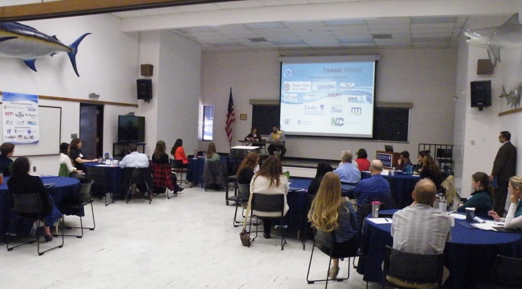
On March 5th, the Duke University Chapter of The Coastal Society hosted the first North Carolina Coastal Career Day at the Duke Marine Lab in Beaufort. The event attracted undergraduate, graduate, and professional students from many North Carolina universities, including Duke, University of North Carolina Wilmington, and East Carolina University (ECU), as well as new professionals in coastal environmental fields. The day started with casual networking over morning coffee. Attendees were able to chat with representatives from each of the event’s sponsors, which spanned a diverse range of sectors, such as non-profits, consulting firms, engineering companies, and both state and federal government agencies.
Photo Credit: Michelle Covi
Master of ceremonies, Siddartha Mitra of ECU, kicked off the day with welcoming remarks and then a rapid-fire session of presentations and Q&A about how each coastal professional began their careers. These conversations allowed attendees to ask their most burning questions about job searching, the hiring process and possible career paths in an informal and relaxed setting. We got to know each other a bit better during the speed-networking session, which allowed attendees to visit each prospective employer at their table and chat for a few minutes. This really helped break the ice and got the conversations flowing, just in time to enjoy lunch with some new members of our professional network. After lunch, we heard from more coastal professionals who gave us excellent advice on everything from resume writing to negotiating salaries. We finished the day by practicing interview skills with questions picked from a hat. Attendees were able to get instant feedback from professionals experienced in the hiring process.
Master of ceremonies, Siddartha Mitra of ECU oversees conversations between students and coastal professionals. Photo Credit: Michelle Covi
The Coastal Society’s Coastal Career Days provide an opportunity for students to connect with potential employers and learn about the diverse range of paths that can lead to a successful career, including some paths that aren’t so obvious. At the same time, it provides an avenue for Coastal Career Day sponsors to reach out to talented new or soon-to-be professionals with valuable skills and knowledge. Marianne Ferguson of the Duke Marine Lab said, “I appreciated learning about the federal contracting process from Jill Meyer [representative from CSS-Dynamac]. As someone who is interested in working for NOAA in fisheries management, her advice on when and where to look for contracting jobs and what the hiring process is like was really helpful.” Marianne recently followed up on a lead she heard about at Coastal Career Day and applied for a contract job with NOAA.
The first North Carolina Coastal Career Day was a huge success thanks to our planning committee members, sponsors, and attendees. We hope to continue this tradition and provide young professionals and employers the opportunity to connect. After all, we need to work together to solve the problems facing North Carolina’s coast!
North Carolina Coastal Career Day provided many opportunities for networking and learning. Photo Credit: Michelle Covi
The agenda provided ample time for in-depth discussions between students and coastal professionals. Photo Credit: Michelle Covi
Presentations from coastal professionals like Tom Bigford, American Fisheries Society, allowed students to get invaluable advice. Photo Credit: Michelle Covi
By: Tom Bigford, American Fisheries Society Policy Director and TCS Past President, with Erin J. Bryant, Assistant Professor of Ocean and Coastal Policy, Sea Education Association, and Kimberly Hernandez, Coastal Fellow with Maryland Department of Natural Resources*, (TCS Communications Subcommittee Members)
The Best of The Coastal Society (TCS) 2015: community conservation events, career opportunity announcements, networking; TCS does it all for current and future coastal professionals.
#1 The New TCS Blog! Addressing legal issues, legislative action, international events, and coastal management strategies
Credit: TCS
The Coastal Society has celebrated 40 wonderful years of the Bulletin since Volume 1, Issue 1 in May 1976. The blog is meant to fill the space of the Bulletin in an updated format. Members have the opportunity to write about their work, students can write about their research, and Board members can use it as a forum to make Society announcements. Please reach out to Caitlyn McCrary with blog topics.
#2 TCS hosted Coastal Career Day November 14, 2015 at The College of William and Mary in Williamsburg, VA
Credit: TCS
Coastal employers and other professionals met and talked with students about jobs in marine and coastal industry, government, science, and conservation.
The annual Neuse RIVERKEEPER™ Foundation Sprint Triathlon in Beaufort, NC, raises money to help keep the Neuse River basin clean and pollution free. And the organizers and athletes have a pretty good time.
#10 Your favorite chapter events! Send us your news!
Student chapters of the Coastal Society actively pursue coastal management innovation and career advancement activities at Duke University, East Carolina University, the University of North Carolina at Wilmington, Oregon State University, Eckerd College, and the University of Rhode Island
TCS has run its Annual Giving Campaign since 2012, and is now considering a shift from an end-of-the-calendar-year event to a continuous opportunity. The idea has been under consideration since this past Valentine’s Day when we announced our “I Love/Heart the Coast” effort. Additional inspiration was provided by the family of Mo Lynch, our current Treasurer, a very long-time TCS member (since 1976, perhaps the longest membership streak of anyone), a past TCS President, the program lead for TCS16 in 1998 in his hometown of Williamsburg, Virginia, and an extremely fine gentleman and professional friend to many.
Mo Lynch, a pioneer of ocean leadership–then, now, and always
“…an extremely fine gentleman and professional friend to many.”
His family recognized his good deeds and commitment to TCS, so when his 80th birthday approached during our 2015 Annual Giving Campaign, siblings and others sent a flurry of donations to TCS in his name. At last count, TCS had received eight generous donations based on multiples of Mo’s age, all now destined for a good cause. Once again, Mo has provided leadership. Let us all live to 100 and have family members so inclined to donate to our Society!
By: Erin J. Bryant, Assistant Professor of Ocean and Coastal Policy, Sea Education Association, and Kimberly Hernandez, Coastal Fellow with Maryland Department of Natural Resources*, (TCS Communications Subcommittee Members)
Coastal management took some big leaps forward in 2015 in many regions and sectors. Here are a few inspiring highlights, from Washington state to the Caribbean, and from climate change resilience and marine protected areas to green infrastructure technology and citizen science.
What else happened? Send TCS a message so we can pass along your coastal management news. What Was Green in 2015 … in the World of Coastal Management? Or at least noteworthy?
*TCS Leadership and Committee Chairs contributed to this article
#1 Sea Grant Tools Help Communities Become More Resilient
Photo Credit: Sea Grant
In January 2015 Sea Grant launched the National Sea Grant Resilience Toolkit. The toolkit is a compilation of tools and resources that have been developed over the years by the Sea Grant Network to help local communities become more resilient.
Restore America’s Estuaries and the Connecticut Institute for Resilience and Climate Adaptation held the first gathering of the living shorelines community after NOAA’s Living Shorelines guide outlined how to promote living shorelines as a shoreline stabilization technique to preserve and improve sheltered coastline habitats and the benefits they provide. New research finds that wetlands, marshes, and other natural barriers are more effective than concrete at protecting coasts.
#3 NOAA, federal partners design ‘early warning system’ for freshwater toxic algal blooms
Photo Credit: NOAA
The National Oceanic and Atmospheric Administration will study satellite data information on Harmful Algal Blooms to protect freshwater from contamination and help protect the American public.
The Verified Carbon Standard (VCS) will now allow salt marsh, seagrass, mangrove, and other tidal wetland restoration projects to count for carbon credits.
#5 Rhode Island’s Block Island offshore wind farm set to be first in nation
Photo Credit: Deepwater Wind
The first offshore wind farm in the United States, the 30 megawatt, 5 turbine Block Island Wind Farm in Rhode Island is scheduled to be online in 2016. Soon, the Block Island Wind Farm will not only supply most of Block Island’s power, but also reduce air pollution across southern New England for years to come.
#7 The Great Lakes Restoration Initiative Report to Congress and the President summarized the GLRI’s first five years of study, restoration and management
Photo Credit: Michigan Dept of Environmental Quality
Toxic substances, invasive species, non-point sources of pollution, research, evaluation, outreach, and partnerships are GLRI’s focal areas.
#8 EPA’s Green Infrastructure Wizard, or GIWiz, provides access to tools and resources that can support and promote water management and community planning decisions
Photo Credit: EPA
GIWiz is an interactive web application that connects communities to EPA Green Infrastructure tools & resources. Users can produce customized reports.
#10 Georgia Sea Grant Uses New Smartphone App to Map King Tide Flood
Photo Credit: Georgia Sea Grant
The Sea Level Rise app, created by Norfolk, Virginia-based Wetlands Watch and developer Concursive, is being pilot tested to capture tidal flooding events up and down the East Coast, including by Sea Grant programs in South Carolina, North Carolina, Georgia and Florida.
#11 Smart Coastal Management in Washington: Coastal Hazards Resilience Network and Marine Spatial Planning Move Forward
Washaway Beach
Photo Credit: Washington Coastal Hazards Resiliency Network
The Washington Coastal Program’s new regional partnership boosted coastal community resilience by helping local planners find tools for disaster response and recovery. Washington moved toward a comprehensive marine spatial plan by mapping seabirds, mammals, and seafloor features.
#12 California Sea Grant and the California Coastal Commission produced Sea Level Rise Policy Guidance
Photo Credit: California Coastal Commission
http://www.coastal.ca.gov/climate/slrguidance.html
California’s Sea Level Rise Policy Guidance document briefs the best available science on sea level rise for California and tells the Coastal Commission how to plan and regulate for sea-level rise. The guidance document makes general recommendations intended to be adapted to the needs of specific geographical areas. Sea Grant and CCC will periodically revise the guidance document to address new sea level rise science, information and approaches to sea level rise adaptation, and new legal precedent.
#13 Planners prioritized resiliency in 2015’s Florida Transportation Plan as leaders saw projections of 6-10 inches of sea-level rise by 2030
The 2015 update estimates sea level rise of between six and ten inches above the 1992 mean sea level by 2030
Photo Credit: Florida Department of Transportation
Climate resilience features prominently in the December 2015 update of the Policy Element of the Florida Transportation Plan, which defines goals and objectives for the next 25 years and establishes the policy framework for expenditure of state and federal funds. Included in the plan’s seven policy goals is “Agile, Resilient, and Quality Infrastructure,” with the objective to “increase the resiliency of infrastructure to risks, including extreme weather and other environmental conditions.” Southeast Florida Climate Compact’s projection guideline now includes a long term planning horizon to the year 2100 and local sea level rise rates due to local processes.
#14 Climate Central announces America’s Preparedness Report Card
Massachusetts gets an A in climate change impact preparedness
Photo Credit: States at Risk: America’s Preparedness Report Card
http://statesatrisk.org/report-card/massachusetts
The States at Risk report found that Florida and Louisiana face enormous coastal flooding threats, far greater than any of the other 22 coastal states. Florida alone has 4.6 million people projected at risk (living in the 100-year coastal floodplain) by 2050. Louisiana has 1.2 million. Overall, states are more prepared for coastal flooding than for any other threat. Florida, however, is not among them. Florida earned an F for coastal flood preparedness, due to its average level of readiness in the face of enormous current and future risks. Louisiana, which is far better prepared, earned a B-.
The Nature Conservancy with help from multiple agencies and organizations like the Caribbean Landscape Conservation Cooperative (CLCC) – one of a network of private-public sector LCC groups created by the U.S. Department of the Interior – identified areas in the Virgin Islands that researchers agreed are most likely to feel the greatest negative impact of global warming and possible ways to mitigate the situation.
It’s been a busy couple weeks for me as I pursue new relationships for TCS, with an eye toward strategic partnerships with some of our more prominent partners. That sounds fuzzy but the intent is clear. Our mission is to address emerging coastal issues by fostering dialogue, forging partnerships, and promoting communications and education.
Since Matt Nixon relieved me of my duties as TCS President, I have shifted my energies to pursuing existing or new partners who share our vision. Here are some of the doors I opened this month (with help from many others):
Social Coast Forum 2016 – I had the honor of moderating the closing plenary session on “It Ain’t All Bad: Promising Programs and Techniques to Address Changing Ocean Conditions.” Thanks to Matt Nixon for organizing the session and the ~30 TCSers I passed in the halls of the Hotel Francis Marion in Charleston, SC. I plan to contact each registrant as we discuss possible roles for TCS in the social science realm.
Coastal States Organization Winter Membership meeting in Washington, DC – Attending this event was a nice bonus since I had to bow out of my planned trip to the CSO fall meeting last September in Florida. CSO Executive Director Mary Munson was especially gracious, offering me time to open their meeting with a few words about TCS, our history in coastal communications, and commitment to nurturing young professionals. I plan to write these attendees, too, as TCS needs to have a stronger connection to the state coastal leaders.
National Estuarine Research Reserves Association meeting in Washington, DC – Thanks to TCS Director Erika Washburn for her help in explaining how TCS interests intersect with this program, a place-based subset of coastal management. The reserve community is revisiting how it communicates and partners with others so it was nice for TCS to be present and engaged.
American Shore and Beach Preservation Association – I met with their new Executive Director last summer and followed up by attending portions of their annual meeting. This presented another opportunity to talk about shared interests, especially right on the sandy interface between our upland and seaward interests. Attendees included some familiar faces but also some new friends. We can expect to see ASBPA at the RAE-TCS Summit in New Orleans.
Coastal and Estuarine Research Federation – CERF just welcomed a new Executive Director (Susan Park), along with their new President (Robert Twilley) from last fall. Wearing my TCS hat (nice, from Zazzle; see our website for info) and my American Fisheries Society hat (my employer), CERF invited me to help them shape what might be a policy effort that extends beyond research and toward our arena. These discussions could lead to partnerships down the road, building on our work with the CERF society and their New England affiliate in 2015.
Water Environment Fund – This huge group focuses on water delivery, infrastructure, quality, quantity, and more. They are developing an increasing interest on coastal issues. Thanks largely to efforts by TCS Treasurer Mo Lynch and TCS Director Lewie Lawrence, I have had several calls with their Executive Director, President, and senior staff. We’ll meet again soon. I have high hopes WEF will get involved in the 2016 Summit and perhaps other TCS activities.
So I’m keeping busy with TCS work, and would love to hear from you about opportunities with these groups or other partners to approach.
Note, I didn’t even mention the Coastal Career Day event in Beaufort, NC on March 5 – I’ll leave that to my TCS colleagues who are leading the way on that event. I hope to see many of you there!


 Eckerd College has a small but environmentally conscious student body. The coastal and marine environment proves to be a major draw for Eckerd College students. With over a mile of coastline on our campus alone, students are constantly interacting with the coastal environment. The campus waterfront, situated on Frenchman’s creek near the opening into Tampa Bay, allows students to make regular kayak trips, swimming breaks, and even sailboat rides straight from the school. Service and volunteer work within the community is a high priority for our students, and even part of our graduation requirements.
  The Coastal Society is just one important group on campus that includes a variety of volunteer outreach opportunities. As the first undergraduate program to have a Coastal Society chapter, it provides a great resource and opportunity for students.