Coastal communities are experiencing more
intense storms under a changing climate—this past Atlantic hurricane season was
the third most active in recorded history, hosting one of the five costliest
hurricanes to impact the US. Future storm impacts are predicted to be
exacerbated by continued sea-level rise and population growth along coastlines,
combined with climatic changes breeding favorable environmental conditions for
the development of more frequent intense storms. Building coastal community
resilience is thus continually placed on local, state, and federal agendas, and
it served as the subject of the Coastal Society’s (TCS) Coastal Connections
session, held on October, 21, 2021. A recording of the session is availablehere.
TCS President, Steve
MacLeod, initiated the session by familiarizing attendants with TCS and the
Coastal Connections web series and then inviting attending Board Members to
introduce themselves. The session was moderated by Kim Grubert, Project
Consultant on the Sustainability, Energy, and Climate Change team at WSP USA,
Inc. and TCS Chapters Committee Co-Chair. Presentations were then given by the
following panelists: Erik Heden, Warning Coordination Meteorologist at
the National Weather Service Forecast Office in Newport/Morehead City, NC, and
Jill Gambill, Coastal Resilience Specialist at University of Georgia Marine
Extension and Georgia Sea Grant.
Erik Heden provided an overview of the
National Weather Service’s (NWS) extensive community outreach initiatives. NWS
organizes hurricane outlook talks with core partners that provide information
on potential hurricane impacts. During Hurricane Preparedness Week in May, NWS
conducts outreach that includes messaging related to developing an evacuation
plan, assembling a disaster supply kit, and getting flood insurance (more
information is available athttps://www.weather.gov/wrn/hurricane-preparedness).
NWS also organizes outreach talks for schools and community groups that offer
safety information related to rip currents, floods, lightning, and hurricanes.
Mr. Heden also touched on the efforts of the NWS Newport/Morehead City office,
which coordinates with NC Sea Grant to provide information related to sea-level
rise and potential impacts. Specific outreach requests include providing talks
for military professionals related to hurricane preparedness and outreach
booths at community events. New outreach efforts include NWS hurricane
community forums (in-person and virtual) that focus on sharing key preparedness
messages and the Weather Ready Nation Ambassador program to support community
engagement. NWS Tropical SKYWARN and Integrated Warning Team training are also
available. For more information on flood risk and outreach efforts, visit
weather.gov.
Jill Gambill discussed NOAA Georgia Sea
Grant’s efforts related to coastal resilience planning for coastal storms and
sea level rise. In coastal Georgia, more than 10 inches of sea-level rise has
been measured at the NOAA Fort Pulaski tide gauge since 1935. Tide gauge data
supports that the frequency and magnitude of flooding in coastal Georgia are
increasing, and the regional rate of sea level rise is accelerating. Sea Grant
is working to increase community capacity and mitigate risk to natural hazards.
Current Georgia Sea Grant efforts include diversifying their workforce,
progressing equitable access to resources and decision-making processes, and
seeking community input on communicating flood risk. Georgia Sea Grant, with
funding from NOAA’s Weather Program Office and in collaboration with the NWS,
is developing virtual reality simulations of structural flooding from storm
surge. The platform also provides methods to explore the benefits of different
mitigation measures, such as elevating a home or purchasing flood insurance.
Ms. Gambill also highlighted the importance of considering environmental,
economic, and social benefits of community projects and provided an example of
urban tree restoration efforts in Savannah that have multiple benefits of flood
reduction, heat reduction, workforce development, and youth engagement.
To continue the TCS discussion of climate
change challenges for coastal communities, our next Coastal Connections session
will be focused on sea level rise. The
Coastal Connections discussion will be held on Wednesday. March 30th from 3-4pm
Eastern. Join
us to learn about trends in sea level rise, considering recent data in
comparison to the geological record, and participate in a discussion about sea
level rise impacts on coastal resources and general mitigation approaches.
Featured speakers include:
John Englander,
Oceanographer/Author
Molly Mitchell, PhD, Research
Assistant Professor at Virginia Institute of Marine Science
Following presentations, attendees will have
the opportunity to ask questions and share their own expertise in a moderated
discussion. To participate in this free event, please register on Eventbrite at
the following link: https://tcs-coastal-connections-web-meeting11.eventbrite.com
Three women sat slightly sweating with the electricity out, wind pounding the hurricane shutters. Each a daughter from a different generation – Generation Y, Baby Boomer, and one born on the cusp of the Greatest and Silent Generations.
Up until that point our time in darkness waiting for Hurricane Matthew had been like a snow day. Cozy together time with coffee, playing cards, watching the local weather man give updates, and reading books aloud to one another. After two wobbles that took Matthew away from our location, we were relieved to no longer have to think about extreme flooding or whether or not the house could stand up to category 4 winds.
But while others in our area probably went to bed after the second wobble, we stayed up.
One of us had a high stake in the electricity going out.
My 87-year old grandmother, Rae Dolores DePalma (b. 1929 – d. 2017), a long-time sufferer of COPD and congestive heart failure, spent the prior five years transitioning from needing oxygen part of the day, to most of the day, to all of the day. In October 2016, ten minutes off the oxygen could plummet her blood oxygen levels to 50% oxygen saturation – a critical level. Or as one paramedic told us so crudely, “I’ve seen corpses with oxygen levels higher than that.” My mother and I needed to stand guard in case the electricity cut out. Even with the electricity on, we would check her levels using an oximeter at least hourly.
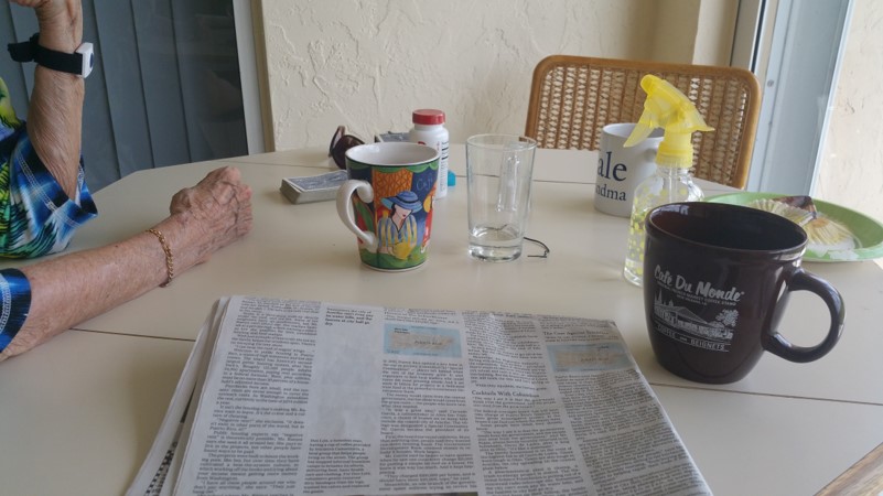
Rae Dolores DePalma
Sure enough, not long after Hurricane Matthew’s second wobble, the TV and lights flickered and we were in pitch darkness. We immediately put our contingency protocol into action.
The oxygen concentrator my grandmother depended on, and that we affectionately called O2-D2, couldn’t operate without electricity. Little green tanks were Plan B. Each could last four hours and we had five tanks. If the electricity would be off longer than 20 hours we would have to switch to the large hurricane-supply tank of oxygen in the garage that could last 48 hours. If the electricity stayed off longer than that, Plan C was arranging a ride with EMS to the hospital. Past storms in the area had left my family without electricity for ten or more days. The closest hospital was also in the next town over and in a flood zone, which created additional transportation challenges should the roads be impassable.
At the start of the hurricane season I had made inquiries into the capacity of our area for dealing with special needs patients during hurricanes. I had learned the local senior center was not equipped to allow oxygen-dependent persons into the shelters. And I had been told the County did not have an official special needs shelter.
For us, the only option would be the hospital located in the flood-zone. The hospital administrator assured me the generators in the hospital would be safe as they are located on high ground, not in parking lots, which is sometimes the case for essential facilities in flood-prone areas. (I discovered this to be the case while mentoring a group of Worcester Polytechnic Institute students conducting a critical infrastructure analysis in San Juan’s coastal zone.)
Why didn’t we evacuate?
During the hurricane, my mother and I would occasionally speak in whispers so as to not to alarm my grandmother that we should have evacuated. I was witnessing risk perception study results come to life. A couple of times prior to the hurricane, I had presented to my family the reasons I felt we should evacuate. I used flood map tools from the county and explained how stormwater infrastructure functions and the uncertainties in flood modeling. Our house is located one mile from the evacuation zone and in the middle of a series of man-made retention ponds and rivers. Our neighbors were claiming that past hurricanes had flooded the streets but none of the floods went up to the doors. To me this meant a Category 4 certainly could have inundated our houses given the right conditions (storm surge direction and height combined with high tide, heavier than expected rainfall, debris clogged sewers, and overtaxed storm water retention basins). We also had family on the west coast of Florida so, unlike many others, we wouldn’t have to pay for a hotel.
The concern written all over the faces of the local horsewomen of the city had me even more worried in the days leading up to Hurricane Matthew’s arrival. They had been through this time and time again, yet this time seemed different. My sister and her friends spent hours preparing a concrete barn of a friend for extra horses, making sure no flying debris could injure a horse. Those who had non-concrete barns often relocate their horses to concrete barns during storms, if they don’t evacuate to Florida’s west coast. At the concrete barn, my sister and her friends boarded up the stalls, secured feed and water, and transported horses from other unfortified barns.
In the end, I was out-voted. It was considered to be too much of a production to transport all three of us plus two dogs to the west coast with a car full of oxygen tanks, the concentrator, wheelchair and walker, only to pack it all up again and return a few days later. With most of the coast evacuating we could be stuck in traffic for so long the green tanks would run out before we got there. Plus, in and out of cars for short trips, let alone long trips, was really taxing on my grandmother and the anxiety and stress was not good for her heart. It was already working overtime because of her COPD.
During the storm, before the two wobbles, we realized the big risk we took in the decision to stay. I couldn’t help but think of those studies that discuss how even with information (in this case, coastal scientist family member sitting there in the living room with maps and hurricane data discussing the risks) people will tend to listen to neighbors, local weather men or sheriffs before the scientists. Because we were not directly in the evacuation zone these public figures were not focusing their recommendations for our area. They repeatedly pleaded with residents and businesses in evacuation zones to evacuate. The Governor of Florida even went so far as saying, “If you stay, you will die.” I called the County emergency hotline to get advice for our area but they would not give me a specific recommendation, most likely for liability reasons. They did, however, reiterate the information I already knew and discussed the different scenarios. It was nice to have that peer review of what I was telling my family, but because we were one mile outside the evacuation zone we were left to determine our risk independently.
Our neighbors were all saying before the storm that the last hurricane wasn’t so bad. In my family we have been through so many other storms some felt we could get through anything. Days after the storm it was like memories were jogged and new stories came up about bad damage and flooding from past hurricanes.
The Human Factor
In the hours leading up to the storm while getting the shutters closed-up, and all the supplies out of the hurricane supply cabinet, including our low-sodium snack options for my grandmother, I started getting really nervous. Thinking of all the possible scenarios, and mostly the worst case scenarios, I started making an emergency bag for us and my grandmother in case we had to rush to the hospital or be rescued. The bag had an emergency whistle and skin suit in case the flooding got to be really bad, first aid kit, extra Depends, change of clothes, money, identification and insurance cards, water, snacks, waterproof bag for cell phone. My mother thought I was nuts, but I just kept thinking of all the possible scenarios and wanting to be prepared for each.
I am so thankful we never had to use the emergency bags. But I remember my thoughts as I was packing them. “This is ridiculous, why didn’t we evacuate?” “Maybe we should have put sand bags at the front door, garage door, and back door” “What if the river behind the house floods and comes in through the back?” “What if the ambulance can’t get through?” “What is my family thinking?”
I have focused on disaster risk reduction for the past nine years, in various roles in school and professionally. I have researched and written about vulnerable populations and have facilitated teams to develop recommendations from scientists, planners, and municipalities to improve conditions along the coasts and enhance resilience. In West Sumatra, Indonesia I helped during tsunami and earthquake trainings of small businesses along the coasts. But going through an acute event with an elderly, oxygen-dependent loved one, opened my eyes to the real challenges individuals and communities face in implementing recommendations. It is one thing to study and synthesize information from subject matter experts, maps, and models or even to go through hurricanes yourself; it is quite another thing entirely to go through a major hurricane as a caregiver.
I think this “human factor” is something I was failing to consider while I was disgruntled with my family members for making what I thought to be a poor decision.
But more than that I think it is something we do not consider enough in disaster risk reduction and climate adaptation work as professionals. We look at vulnerable populations as statistics and identify measurable barriers that prevent them from taking safety precautions to protect life and property. While we are far from cold to the realities and challenges of these populations, we do have the tendency to down-play the human side to the choices people make when it comes to their health and safety of themselves and loved ones.
Academically, we like to state what people should do or should not do in post-storm event analyses, and describe the poor choices that are made. When extending this work to climate change adaptation, this tendency can be more pronounced in that within community of practice circles we often express disbelief at the decisions made by individuals, businesses, and governments in siting infrastructure, removing natural protective features, or choosing to live in high-hazard areas rather than supporting planned retreat. We tend to think that if they just had the information or if the information was presented better they would choose differently. I don’t think this is necessarily the case. Vulnerable populations need the information to ensure they are making decisions with all the available information, but we need to recognize that affected individuals and communities may still make decisions we disagree with because they weigh certain factors differently than we do as outsiders. When you don’t have a direct stake in the matter, it is not so easy to understand why certain decisions get made the way they do.
In the case of Hurricane Matthew and my grandmother, her discomfort and anxiety and preference to be at home during an emergency rather than in the middle of a gridlocked highway during an emergency, was weighed more heavily than flood and wind risk.
This reminds me of my favorite scene in the movie Sully, about the Miracle on the Hudson. An investigation was launched around the decision made by the Captain to do an emergency landing in the Hudson River instead of trying to make it back to the runway after a flock of birds flew through the engines. The flight simulators showed it was possible to make it back to the runway. But the simulations didn’t consider the real-life response time of a pilot in that situation. Once they did, the simulation results supported the decision made. Tom Hanks, playing Captain Chesley ‘Sully’ Sullenberger, replies in the movie, “We’ve all heard about the computer simulations, and now we are watching actual sims, but I can’t quite believe you still have not taken into account the human factor.”
When the electricity was restored and Hurricane Matthew’s winds were far away, my mother and I were finally able to stop holding our own breaths while trying to save my grandmother’s. I don’t think I will ever look at risk perception or special needs population work in the same way again.
How to Prepare if You are an Older Adult or a Caregiver
A number of organizations and companies have great advice and check-lists for hurricane preparation if you are a caregiver or if you are a senior yourself:
Elderly special needs plans to be ready for a disaster: FEMA
Personal preparedness for older adults and their caregivers: CDC
Editors’ Note: This story is the third contribution to the TCS Storm Stories series. Due to recent hazards events, Hurricane Matthew and the Baton Rouge Flooding, we want to know how it is affecting you personally and in your work. There’s been lots of attention by national media outlets like NPR story Hurricane Matthew Took a Big Bite Out of Southeastern States’ Beaches but since we are a society of coastal professionals for coastal professions we think we should do our own reporting. Sharing experiences and lessons within our network is what we do best. Submit yours today!
By Amanda Leinberger, NOAA Coastal Management Fellow with the Puerto Rico Coastal Zone Management Program and TCS Communications Subcommittee Member.
Editor’s Note: This article is also published on Marine Science Today as part of a TCS-MST Collaboration.
Ecosystem-based Adaptation is good for communities and the environment as it promotes community engagement, restores natural habitats, and builds local resilience. The experience of a small island in the Caribbean is case in point.
Map of the Lesser Antilles. Photo credit: Google.
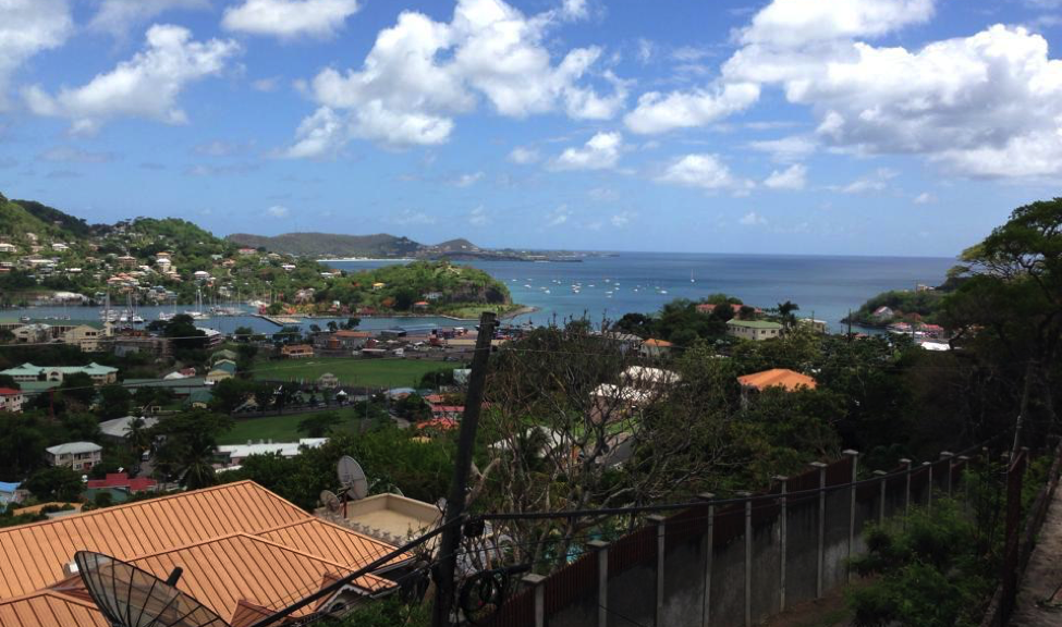
In the turquoise waters of the Eastern Caribbean Sea sits Grenada, a small island of about 105,000 people. The island is the southernmost of the Windward Islands and is located between Saint Vincent and the Grenadines to the north and Trinidad and Tobago to the south. Due to its location, Grenada is prone to natural hazards such as hurricanes, floods, earthquakes, landslides, and tsunamis. The country’s two largest cities, St. George’s and Grenville, are both located on the coast, and people depend heavily on agriculture and tourism for sources of income.
Coastal communities and marine resources on the island have already begun to experience the effects of climate change and are currently at risk from an increase in severe storm events, flooding, sea level rise, coastal erosion, drought, saltwater intrusion of coastal aquifers, and degradation of coral reefs. High coastal population densities, development, and limited land space have made Grenada all the more vulnerable. Damage from events that included two hurricanes, various tropical storms, and multiple extreme rainfall events served as a catalyst for projects focused on disaster preparedness, coastal resilience, and Ecosystem-based Adaptation (EbA) to help protect communities at risk from future coastal hazards.
According to the International Union for the Conservation of Nature (IUCN), adaptation can occur in physical, ecological, and human systems and “takes place through reducing vulnerability or enhancing resilience in response to climate change.” Adaptation activities include increasing community members’ knowledge and awareness about climate change effects to actually implementing adaptation strategies like creating a rain garden to help improve stormwater management.
EbA specifically focuses on “the conservation, sustainable management, and restoration of ecosystems to help people adapt to the impacts of climate change (IUCN)” as opposed to hard strategies that sometimes work against natural processes, such as concrete seawalls. EbA, also known as nature-based adaptation or a soft adaptation strategy, consists of multiple co-benefits as it not only protects livelihoods and communities but also restores natural habitat, supports vital ecosystem services, and boosts economies by increasing tourism.
Photo credit: Tom McCann, The Nature Conservancy (found in National Geographic Ocean Views, 2014).
The At the Water’s Edge (AWE) project, a great example of EbA work in the Caribbean, promotes coastal resilience and aids local communities in Grenada in responding to coastal hazards. As part of AWE, a partnership was formed between The Nature Conservancy, the Grenada Red Cross Society, and the Grenada Fund for Conservation as well as other local partners to conduct a Vulnerability Capacity Assessment (VCA). Combining the strengths of these different organizations helped make the process not only nature-based, but community-based as well. The VCA focused on four communities in the Grenville area of Grenada on the east coast of the island: Marquis, Soubise, Grenville, and Telescope. Previous assessments of these sites showed them to be the most vulnerable areas in Grenada for various reasons including their location, dependence on marine resources for income, and damage caused by past extreme events and storms. These communities are situated just steps away from the ocean, leaving them more susceptible to future changes.
Example of mangrove restoration on east coast of Grenada. Photo credit: Amanda Leinberger, 2014.
The AWE project represents a holistic, community-based approach to adaptation and coastal management processes. For example, the project used participatory 3-dimensional mapping, which is a method of community based-mapping. The map depicts local knowledge and information like landmarks, houses, resources, and ecological features that would be difficult to express on a traditional or even a digitized map. Community members also attended various meetings and trainings as well as formed part of a community committee that was responsible for leading projects and making decisions.
Under this same project, two main EbA approaches were implemented in the Telescope area: mangrove restoration along the shoreline and a pilot coral reef enhancement project off the coast. On an island like Grenada where mangroves occur naturally but have historically been cleared for development, replanting mangroves can bring back a wealth of benefits such as protection from waves, water filtration, and fish habitat. The reefs off the coast of Grenada have also been degraded due to climate change effects as well as land-based pollution sources. The reef enhancement project’s goal was to help with wave attenuation, meaning to
decrease the amount of wave energy reaching the shore thereby decreasing coastal erosion and the risk of damage during high tide and storm surge events.
Climate adaptation often elicits images of giant seawalls separating cities from the sea. Gray infrastructure projects like seawalls are expensive, and they can lead to negative ecological and social impacts like disruption of sand distribution, loss of beach, and elimination of natural habitat. EbA, or green responses, are more sustainable than traditional hard approaches in more ways than one. The work in Grenada demonstrates the importance of natural infrastructure and can serve as an example not only to other Caribbean islands, but to coastal communities around the world.
By Thomas E. Bigford, TCS Past-President and Policy Director for the American Fisheries Society
We were impressed by an October email from Derek Brockbank, Executive Director of the American Shore and Beach Preservation Association (ASBPA; www.asbpa.org). Derek was sharing his recent experience with Hurricane Matthew and the messages he conveyed to ASBPA members, coastal professionals, and the public. We thought much of his message applied equally to our coasts. With a gracious nod to our friends working in the dunes and on beaches, we thought it would be valuable to share his ideas. Perhaps you can use some of his points to remind those with coastal interests just how important these issues are.
Derek’s primary message had four parts (adapted slightly here for our consideration): (1) Weeks after the storm, jurisdictions were still assessing damage; (2) Beaches/dunes protected coastal property from greater damage; (3) Beaches are part of the network of geological features that provide broader coastal protection; and (4) Society needs a systemic plan to protect existing coastal features (dunes, beach, mangroves, coral or shellfish reefs, etc.) and to increase natural resilience.
Derek also offered some background on his four points:
1) Local coastal managers are still assessing damage to determine what will recover naturally and what will need help to be restored to a healthy state.
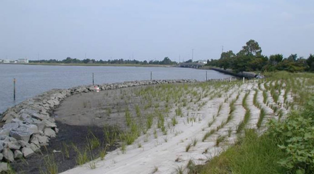
2) We know that Beaches and Dunes did their job – they protected property and lives at the expense of displaced sand – communities without beach and dune systems fared much worse.
Beaches and dunes are the first lines of defense for coastal communities and ecosystems. Photo Credit: Kasey R. Jacobs
3) Beaches and dunes are the first line of defense, but coastal flood and storm protection takes multiple lines of defense. During Hurricane Matthew, mandatory evacuations saved lives; elevated homes saved property.
a. Bayside flooding can be nearly as destructive as oceanfront, but proper planning – including wetland and bay beach restoration, storm-sensitive building codes and beneficially using navigation channel sediment – can reduce risk.
b. Inland flooding from excessive rain during a coastal storm can be tremendously destructive, so resilience planning must be systemic and watershed-based.
4) As seas rise and coastal storms intensify, post-storm restoration must be looked at systemically and with the goal of increasing resilience throughout the watershed. Federal support will be necessary to help local communities while ensuring efficient and systemic recovery and restoration, not just piecemeal rebuilding.
The ASBPA continues to spread its message, a task TCS could assist by developing our own recommendations. That work could be handled by one of our stalwart committees, perhaps supplemented by TCS members well versed in these issues. Not surprisingly, the resulting products would probably look quite similar to the ASBPA actions:
Issue a press release to enlist help from outlets such as radio and print.
Consider submitting editorial pieces to local newspapers.
Offer a stakeholder call or special membership to affected communities to share experiences and offer technical advice.
As we learn more about this storm, our changing coasts, and possible TCS roles, we will consider:
Compiling facts and data to document losses, needs, etc.
Join others to organize Hill briefings on coastal impacts
Use this unusual event to inspire communications, set priorities, improve strategic plans, and train the next generation of coastal professionals.
TCS members can join this effort by sharing experiences related to any of these ideas. We think a great contribution would be to document in words and images our successes – protective barriers (natural or otherwise) that held through the storm, restoration techniques that survived wind and rain, public messages that resonated with local citizens and governments, and so much more. Be thoughtful. Be creative. Be ready for the next big one!
Editor’s Note: This story is the second contribution to the TCS Storm Stories series. Due to recent hazards events, Hurricane Matthew and the Baton Rouge Flooding, we want to know how it is affecting you personally and in your work. There’s been lots of attention by national media outlets like NPR story Hurricane Matthew Took a Big Bite Out of Southeastern States’ Beaches but since we are a society of coastal professionals for coastal professions we think we should do our own reporting. Sharing experiences and lessons within our network is what we do best. Submit yours today!
By Guest Contributor Keni Rienks, high school teacher at Cape Fear Academy in Wilmington, NC.
Photo Credit: Keni Rienks
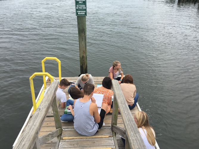
North Carolina has spent its share of time in the media forefront lately, and thanks to Hurricane Matthew it will continue to make headlines for a bit longer. Extending from the Appalachian Mountains through the Piedmont to the coast, North Carolina’s variety of environments make it an intriguing and characteristic part of the United States’ southeast corner. As a high school environmental science teacher in Wilmington, I tend to gravitate towards curriculum centralized around our estuaries and watersheds. Being at the mouth of the large Cape Fear River Basin provides opportunities for me and my students to share experiences regarding freshwater ecosystems as well as the complexity and importance of our barrier island and estuarine habitats. One of my most rewarding and impactful lessons is working with my students in water quality tests and monitoring.
Photo Credit: Keni Rienks
The Advanced Placement Environmental Science topic list requires students to acquire knowledge of and experience in water quality, which I aim to personalize for the students. The majority of my student body lives well within a short drive of the ocean, and many of them spend a lot of time in and on the water. We travel in the fall and late spring to various locations on the Intracoastal Waterway and the Atlantic shoreline to perform a series of biological, chemical, and physical water quality assessments. The research process begins with students accessing the published 2015 Environmental Quality of Wilmington and New Hanover County Watersheds, by Dr. Michael A. Mallin and Matthew R. McIver from UNCW’s Center for Marine Science. Dr. Mallin’s advice and communications have been a key component in my teaching and students’ content acquisition regarding the importance of monitoring the health of our local water system.
The City of Wilmington’s Stormwater Education Program Manager, Jennifer Butler, is also a great advocate for storm water education. Ms. Butler oversees the “Heal Our Waterways” program with coordinator Geoff Goss. Mr. Goss monitors two particularly impaired sub-watersheds, and he heads a community outreach program aimed to educate residents within the watershed about protection and monitoring (and, hopefully, the eventual healing) of the watersheds. Many of my students live within these particular areas, so I have integrated the “Heal Our Waterways” curriculum and resources into my AP Environmental Science Classroom. This program’s materials help teachers provide students with an applicable, real-world experience. Being able to monitor and study the water quality of these waterways is a great opportunity for citizen science.
The week before Hurricane Matthew hit the Cape Fear region, a group of 50 high school juniors and seniors performed a series of water quality tests on the Atlantic Intracoastal Waterway in an area that is at the mouth of Whiskey Creek. This creek is within a higher-end residential area with an upscale marina, and it is also a public park and boat launch. Students examined the presence of fecal coliform, dissolved oxygen, pH levels, nitrates, phosphates, biochemical oxygen demand, and salinity. They then compared their data with the 2015 Environmental Quality of Wilmington and New Hanover County Watersheds report, and composed an official laboratory report for a grade. Results were then shared with Dr. Mallin and the City of Wilmington.
Photo Credit: Keni Rienks
At the time of this writing, we are one week past the hurricane, but water and contaminants from the floods are still streaming down the Cape Fear River Basin and into our estuary. Though I haven’t yet taken students to test sites, I have brought buckets of water into the classroom for testing and comparison for a pre- and post-hurricane assessment. Within the next 3 weeks I plan to get students to the test sites or at least get water into the classroom for examination. While the storm impacts are unfortunate, this is a tremendous opportunity for students to be taking real data, from real situations, and reporting it to real people!
Photo Credit: Keni Rienks
As a high school teacher I am so appreciative of the resources and opportunities from local scientists and organizations that can make what I do in the classroom applicable and real to the students. Tapping into your local schools and science teachers are a great way to apply high quality citizen science!
Keni Rienks is a high school teacher at Cape Fear Academy in Wilmington, NC. Her classes include AP Environmental Science, Honors Physics and Botany. This past summer she served as the Communications Co-Chair for the 4th International Marine Conservation Congress in St. John’s, Newfoundland, sponsored by the Society of Conservation Biology’s Marine Division.
Editor’s Note: This story is the first contribution to the TCS Storm Stories series. Due to recent hazards events, Hurricane Matthew and the Baton Rouge Flooding, we want to know how it is affecting you personally and in your work. There’s been lots of attention by national media outlets like NPR story Hurricane Matthew Took a Big Bite Out of Southeastern States’ Beaches but since we are a society of coastal professionals for coastal professions we think we should do our own reporting. Sharing experiences and lessons within our network is what we do best.