TCS Coastal Connections Web Meeting on Natural Marine Sanctuaries

By Ashley Gordon

From the majestic depths of the ocean to its vibrant coastlines, our planet’s marine ecosystems have long captivated the human imagination. Recognizing the profound significance of these underwater wonders, national marine sanctuaries (NMS) emerged as beacons of conservation and exploration. Serving as underwater havens for biodiversity and cultural heritage, these sanctuaries embody our commitment to safeguarding the natural treasures that lie beneath the waves. As our world faces mounting environmental challenges, the importance of these sanctuaries has never been more evident. This vital conservation measure was the topic of the fifteenth session of The Coastal Society Coastal Connections Web Series, held on Thursday, February 23rd through Zoom.

This session saw twenty-one attendees that included both current TCS members and non-TCS members. Steve MacLeod, TCS Past President, kicked off the session by providing a brief overview of TCS and the Coastal Connections web series. The session was then moderated by Ellen Brody, Regional Coordinator of the Eastern Region of the NOAA NMS Program. Ellen provided a brief history of the NMS. NOAA’s National Marine Sanctuaries Program recently celebrated its 50th anniversary in 2022. In 1972, the National Marine Sanctuaries Act was passed, which also coincided with the Coastal Zone Management Act. In 1974, the first NMS was designated after the discovery of the USS Monitor. Ellen then touched on the current state of the NMS Program and how it works. As she explained, the current NMS landscape covers more than 620,000 square miles of ocean and Great Lakes waters (map of current sanctuaries available here). NMSs support resource protection, research and monitoring, education and outreach, and community engagement. Sanctuary Advisory Councils are established for each NMS that bring together a variety of interests and provide advice to the NMS program.

This session’s panelists included Paul Michel, Regional Policy Coordinator for the West Coast Region, and LeAnn Hogan, Regional Operations Coordinator for the Eastern Region, who shared examples of how NMS make a difference. On the west coast, the NMS program supported research and the establishment of the West Coast Vessel Speed Reduction (VSR) Program to reduce the number of whale ship strikes. Over 18 global shopping companies and 559 ships have participated, resulting in a 50% reduction in ship strikes on whales and the additional benefit of greenhouse gas reduction. In the Florida Keys, the Damage Response and Restoration Program of the Florida Keys National Marine Sanctuaries supports addressing impacts from vessel groundings, including vessel and debris removal and seagrass and coral reef restoration.

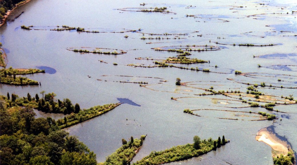
Another key discussion topic was the evolution of the NMS system over time. In 2014, a new approach to NMS system expansion was established that focused on a community-based process. Communities submit a nomination to NOAA that is then reviewed and, if accepted, placed on the NMS inventory. In addition to recent sanctuary expansions (Flower Garden Banks) and new NMS designations (Mallows Bay-Potomac River and Wisconsin Shipwreck Coast), the panelists discussed the following proposed NMS:

  • Chumash Heritage (lead by Paul Michel) – Located in the Pacific Ocean off the San Luis Obispo and Santa Barbara County coastlines, this area is ecologically rich and dynamic with unique geomorphological features and historic shipwrecks. Proponents of the sanctuary, the Sierra Club, Surf Rider, and the Northern Chumash Tribal Council, highlighted a myriad of issues the NMS could address and the importance of recognizing Indigenous heritage and cultures. The NMS program is working to involve Tribal Bands in collaborative management approaches.
  • Hudson Canyon (lead by LeAnn Hogan) – Located in the Atlantic Ocean off the coast of New York and New Jersey, this ecological hot spot serves an important economic role for commercial and recreational fisheries. The Wildlife Conservation Society submitted the nomination. Given the large number of stakeholders engaged in this area of the ocean, the Hudson Canyon process has included a collaborative public scoping process to identify the potential NMS boundaries.
  • Eastern Lake Ontario (lead by Ellen Brody) – The nomination was submitted by four counties and the City of Oswego with support from the State of New York and focused on maritime heritage resources. As part of this designation process, NMS is working with the Haudenosaunee Confederacy to re-establish their connection with their ancestral lands. The notice of proposed rulemaking was recently published, and it is anticipated the designation will be finalized in a year.

Following these presentations, the group discussed topics that included regulations and enforcement within NMS, the selection of NMS and pace/prioritization for going through the designation process, and coordination with fisheries management and offshore wind development.

Overall, this session facilitated a fruitful conversation about a conservation measure of ever-increasing importance. NMS stand as vital guardians of our marine heritage, inspiring us to protect and preserve these fragile ecosystems for future generations. We learned a lot from our panelists, and the results from our post-event survey revealed that our participants did too—100% of respondents found the event to be extremely informative! With another successful TCS Coastal Connections in the books, we look forward to seeing you at the next one.

The session was recorded and posted on the TCS YouTube channel here: https://www.youtube.com/watch?v=bB6IH2Cvmo4

THE GHOST FLEET OF MALLOWS BAY: A NEW NATIONAL MARINE SANCTUARY?

By Kim Hernandez, Coastal Resources Planner at the Maryland Department of Natural Resources. This article is also published on Marine Science Today as part of a TCS-MST Collaboration initiated earlier this year. 

In the tidal Potomac River, about 30 miles downstream from Washington D.C., lay the remains of the “Ghost Fleet of Mallows Bay” – over 100 wooden steamships built for the U.S. Emergency Fleet as part of the nation’s engagement in World War I. Dozens of other historic maritime resources also rest in the Potomac River, as well as 12,000 year old archaeological artifacts dating back to some of the region’s earliest Native American cultures. The significance of the area was enough to warrant its listing on the National Register of Historic Places in 2015. Now, thanks to abundant community support, it is in the running to become Maryland’s first national marine sanctuary.

One of the World War I shipwrecks visible at low tide in Mallows Bay, Maryland. Photo Credit: Kim Hernandez.

The National Oceanic and Atmospheric Administration (NOAA), the federal agency with authority to designate an area as a sanctuary, for the first time in two decades has been seeking engagement from the American public to nominate areas with significant community support. As nominations are submitted, NOAA reviews each one in several steps and those that pass the review will be added to an inventory of areas NOAA may consider for potential designation as national marine sanctuaries.

The Mallows Bay-Potomac River National Marine Sanctuary nomination was submitted in September 2014 by the State of Maryland with a broad-base of local government and non-government support. The nomination itself included letters of support from over 60 community organizations and individuals. Sanctuary designation would allow NOAA programs to supplement and complement existing state and local programs that aim to protect, study, interpret, and manage this unique area.

The original nomination cited improved opportunities for public access if the area is designated a sanctuary. Photo Credit: Stephen Badger.

In addition to protecting the fragile remains of the shipwrecks, the nomination also cites opportunities to expand public access, recreation, tourism, research, and education. The area is contiguous to the Captain John Smith Chesapeake National Historic Trail, the Star Spangled Banner National Historic Trail, the Potomac Heritage National Scenic Trail and the Lower Potomac Water Trail, allowing paddlers a unique glimpse into our Nation’s history.  Below the water, the area offers important habitat for popular recreational fisheries, including Striped Bass and White Perch. Above the water, ghostly shipwreck hulls jut out and provide perches for migrating waterfowl and thriving populations of Bald Eagles. The middle Potomac River truly is a historic and ecological treasure.

Four months after the original nomination was submitted, NOAA announced it would add the area to the inventory of nominations that are eligible for designation. It is important to note that the original nomination in September 2014 did not designate anything; it only suggested that NOAA consider designation. The January 2015 announcement meant NOAA would now seriously consider a sanctuary in the Potomac River – a huge step forward for the dozens of community supporters.

The ghostly shipwreck hulls lure recreationalists and historians to this area of the Potomac to get a unique glimpse into the past. Photo Credit: Kim Hernandez.

Nationally, the designation process is a separate public process that, by law, is highly public and participatory and often takes several years to complete. Nominated areas go through four main steps with NOAA before it is determined whether they are designated or not: (1) Scoping: NOAA announces its intent to designate a new national marine sanctuary and asks the public for input on potential boundaries, resources that could be protected, issues NOAA should consider and any information that should be included in the resource analysis; (2) Sanctuary Proposal: NOAA prepares draft designation documents including a draft management plan, draft environmental impact statement that analyzes a range of alternatives, proposed regulations and proposed boundaries; (3) Public Review: The public, agency partners, tribes and other stakeholders provide input on the draft documents. NOAA considers all input and determines appropriate changes; and (4) Sanctuary Designation: NOAA makes a final decision and prepares final documents. Before the designation becomes effective, the Governor reviews the documents. Congress also has the opportunity to review the documents.

Many birds, such as the osprey pictured here, have built nests atop the shipwrecks. Bald eagles are also often seen nesting along the shoreline. Photo Credit: K. Thayer.

For Mallow’s Bay, NOAA considered the nomination action until October 2015 when they issued a formal “Notice of Intent” to designate. Along with the Wisconsin – Lake Michigan National Marine Sanctuary, which is going through this same designation process right now, the Potomac River has the potential to be the home of one of the first new national marine sanctuaries designated in nearly 20 years.

In early spring 2016, a federal, state, and local government committee formed to grapple with all of possible management questions a sanctuary designation could spark. Currently, that committee is developing the draft documents required for the sanctuary – including an environmental impact statement and management plan. If all goes as planned, drafts will be available for public comment sometime in late 2016 and designation of this World War I paragon will coincide with the 100-year anniversary of the United States’ entry into the world war, in April 2017.

Sanctuary designation will allow NOAA programs to supplement and complement existing state and local programs that aim to protect, study, interpret, and manage this unique area. Photo Credit: Daryl Byrd.

If designated, the proposed sanctuary would be managed jointly by NOAA, the State of Maryland, and Charles County, Maryland. The original coalition of organizations and individuals at local, state, regional, and national levels that supported the nomination –  including elected officials, businesses, Native Americans, environmental, recreation, conservation, fishing, tourism, museums, historical societies, and education groups – will continue to help mold the vision for the sanctuary and ensure effective protection and management moving forward.


For more information about the Mallows Bay-Potomac River National Marine Sanctuary nomination, visit: http://dnr.maryland.gov/ccs/Pages/mallowsbay.aspx

For more information about the National Marine Sanctuary Program and nomination process, visit: http://www.nominate.noaa.gov/

Kim Hernandez is a Coastal Resources Planner with the Maryland Department of Natural Resources Chesapeake and Coastal Service. She assists with the coordination of state and regional ocean planning, with the planning and implementation of the Mallows Bay – Potomac River National Marine Sanctuary, and with programs that address coastal hazards and climate resiliency. She also serves as the agency representative on a number of planning bodies and stakeholder groups throughout the Mid-Atlantic region.

Editor’s Note: TCS members working on a national marine sanctuary nomination are invited to contribute a story on your proposed site and current efforts moving through the nomination process. Story ideas or full submissions can be sent to the TCS Communications Chair at kaseyrjacobs (at) gmail (dot) com.